
STAKEHOLDER ENGAGEMENT
WE APPRECIATE YOUR PARTICIPATION
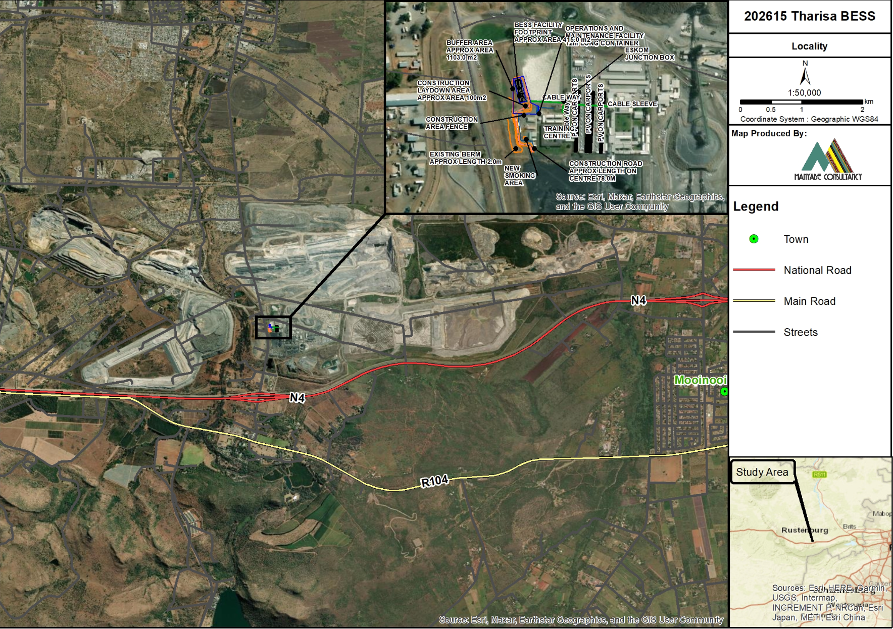
202615 Notice of Registration of the Tharisa Battery Energy Storage System (BESS) Development.
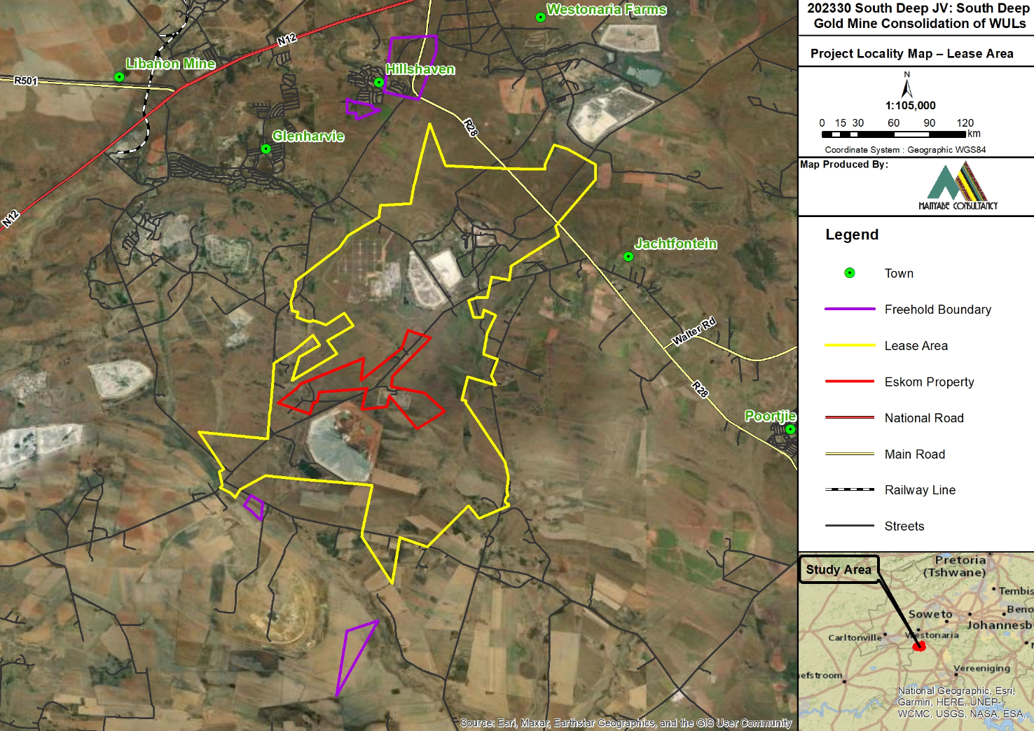
202330 South Deep JV consolidation of WULs – Draft IWWMP in support of the Water Use Licence Application (WULA) for the Consolidation and Amendment of the Water Use License (WUL) and its addendum granted to South Deep JV: South Deep Gold Mine
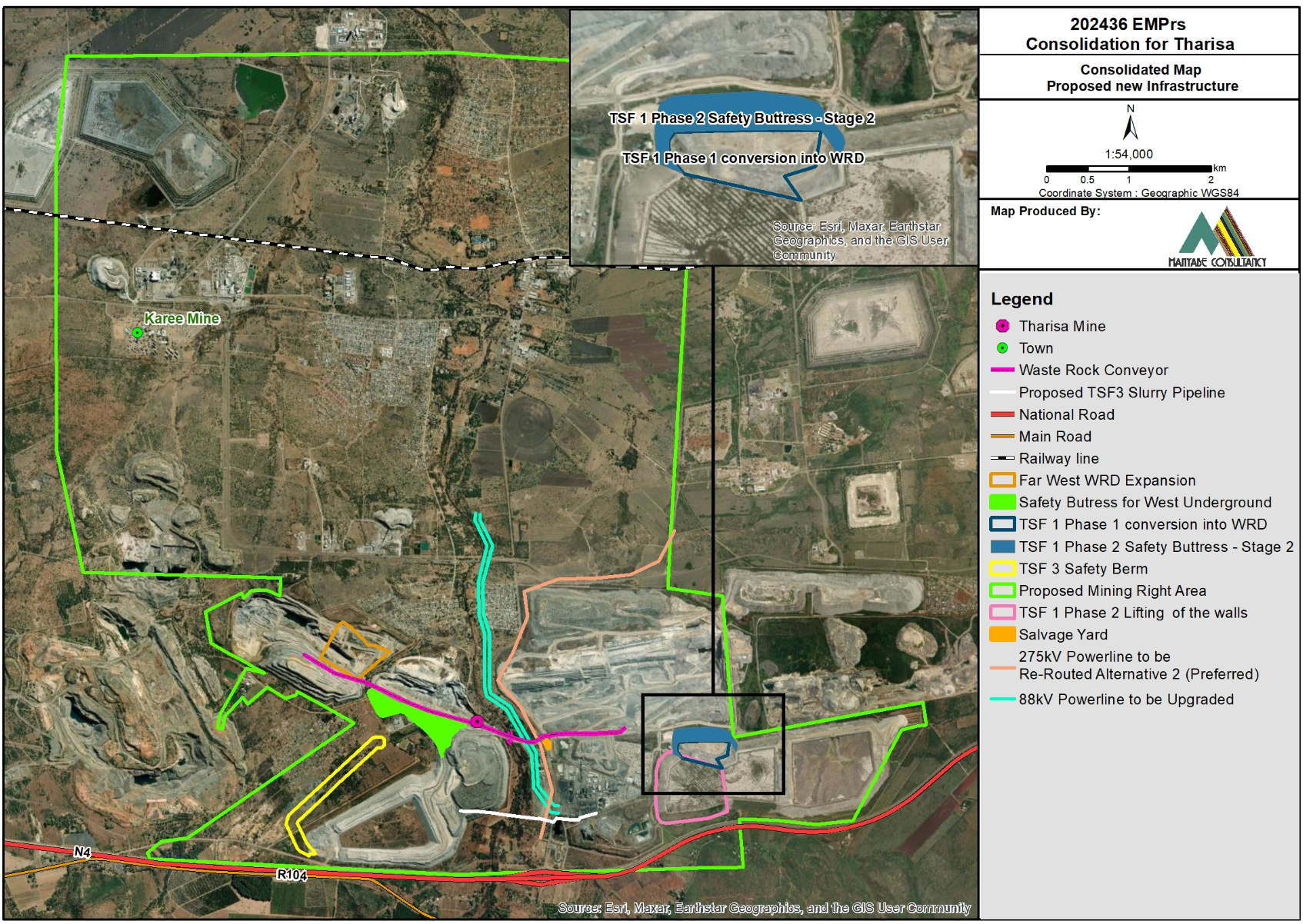
202436 Draft Report for the Consolidation and Amendment of the various existing Environmental Management Programme Reports (EMPrs) granted to the Tharisa Mine, incorporating new Environmental and Waste activities proposed to be conducted for future proofing the mining operation and incorporation of additional properties into the approved Tharisa Mining Right
Draft Scoping Report
Appendices
- 275kVA Powerline Re-routing and 88kVA Upgrade
- Air Quality Monitoring
- Aquatics
- Biodiversity Plan
- Chrome Ore Loading Facilities
- Consolidated Map New Proposed Infrastructure 9 July
- Conveyor from East Pit to Far West OG WRD
- Existing approved WRDs Vs New Proposed WRD
- Existing and approved mining infrastructure at Tharisa Mine pla jul
- Explosive Magazine Storage Area and Emulsion Plant
- External ROM Chromite Ore Loading Area
- Ground Water Quality Monitoring Points
- Land Tenure Map
- Locality approved and Proposed MRA 1
- Locality Proposed MRA
- Noise Monitoring
- Opencast Pits
- Plant Locations
- Quarternary Catchment
- Regional Setting
- ROM Stockpile Area
- Salvage yard versus the old salvage yard
- Slurry Pipeline Route
- Soil Forms
- Soils- Overall Sensitivity
- Soils- Site Land Potential
- Surface Water Quality Monitoring Points
- Terrestrial New
- Tharisa PCDs
- The Proposed Waste Rock Conveyor from East Pit to Far West OG WRD
- Topography
- TSFs to be Incorporated into the Consolidated Project
- Wetlands Deliniation new 9 july
Draft IWWMP Report
Appendices
- Additional Ground Water Monitoring Points
- Biomonitoring Testing Points
- Consolidated Sensitivity
- Current Hydrological Map
- Current Surface Water Monitoring Points
- Delineation Map
- Freehold Boundary Map
- Ground Water Monitoring Points
- Land Tenure
- Locality Map – Lease Area
- Project Ground Water Monitoring Points
- Project Land Tenure
- Appendix C1 – Heritage Screener High-Level Desktop Report
- Appendix C2 – Civil Aviation Compliance Statement
- Appendix C3 – Terrestrial Biodiversity, Plant and Animal Theme Site Sensitivity Verification Report
- Appendix C4 – Agricultural Theme Site Sensitivity Verification Report
- Appendix C5 – Aquatic Biodiversity Theme Site Sensitivity Verification Report
Environmental Management Programme (EMPr)
Appendices
Draft Basic Assessment Report
Appendices
- Appendix 7-1: Terrestrial Biodiversity (Vegetation) Assessment
- Appendix 7-2: Fauna Species Assessment
- Appendix 7-3: Aquatic Compliance Assessment
- Appendix 7-4: Heritage Impact Assessment
- Appendix 7-5: Geological Comparison Report Preliminary Report
- Appendix 7-6: Air Dispersion Modelling Study Report
- Appendix 7-7: Necsa MPR Geotech Geophysics Part 1 Report
- Appendix 7-8: Phelindaba Site 1 and 15 Veg Rehab input
- Appendix 7-9: Civil Aviation Compliance Statement
- Appendix 7-10: Defence Compliance Statement
- Appendix 7-11: Agricultural Potential Compliance Statement
Draft Basic Assessment Report
Appendices
Appendices
202403 Ngatia S24G Report
Appendices
- Annexure A – Preliminary PPP
- Appendix 8-1 Wetland Functional and Impact Assessment Report
- Appendix 8-2 Terrestrial Biodiversity Compliance Statement
- Appendix 8-3 Landscape Maintenance Rehab Plan
- Appendix 8-4 Hydropedological Assessment Report
- Appendix 8-5 Heritage Screener
- Appendix 8-6 Hydrogeological Baseline Assessment Report
Draft Basic Assessment Report
Appendices
- Appendix 1 – Proof of Site Notice
- Appendix 2 – Written Notices issued
- Appendix 3 – Proof of Newspaper Advert
- Appendix 4 – Communications to and from I&AP
- Appendix 5 – Minutes of any stakeholder meetings
- Appendix 6 – CRR
- Appendix 7 – Comments from I&APs on BAR
- Appendix 8 – Comments on amendments to the BAR
- Appendix 9 – Copy of the register of I&APs
Final EIA and EMPr Report
Appendices
- Air Quality Monitoring
- Aquatic Biodiversity Spatial Plan
- Available groundwater locations from hydrocensus
- Biodiversity Plan
- Ground Water Quality Monitoring
- Land Tenure Map
- Locality Map
- NFEPA Wetlands
- Noise Monitoring Location
- Quarternary Catchment
- Recommended Buffers for the identified wetlands
- Recommended Buffers for the identified wetlands 2
- Regional level of protection of aquatic ecosystems
- Regional Setting
- Riparian areas, regulated areas and sensitivity buffers
- Riparian areas, regulated areas and sensitivity buffers 2
- SAIIAE dataset
- SAPAD and SACAD datasets
- Site Ecological Importance
- Soil Forms
- Surface Water Quality Monitoring Locations
- Surface Water Quality Monitoring
- SWAS
- Terrestrial Biodiversity Spatial Plan
- Topography
- Vegetation types
- Wetlands and rivers
- Impact Assessment Phase
- Appendix A : Written Notices issued
- Appendix B : CRR
- Comments received
- CRR
- Public Meetings
- Responses to Comments
- Appendix C : Database
- Appendix D : Website Placing
- Appendix E : Smses Sent
- Appendix F : Delivery Notes
- Scoping Phase
- Appendix A : Proof of Site Notice
- Appendix B : Written Notices issued
- Appendix C : Proof of Newspaper Advert
- Appendix D : BID
- Appendix E : CRR
- Appendix F : Database
- Appendix G : Delivery Notes
- Appendix H : Minutes and Attendance Registers
- Appendix I : Website Placing
- Appendix J : Smses sent
- Appendix A : EAP’s Details
- Appendix B : Copy of the WUL 2024
- Appendix C : Engineering Design Report
- Appendix D : Freshwater Ecology (Aquatic) Assessment, including Wetland Delineation
- Appendix E : Hydropedological Assessment Report
- Appendix F : Hydrological Assessment Report, including Stormwater Management Plan
- Appendix G : Geohydrological Impact Assessment Report
- Appendix H : Site Wide Water and Salt Balance Report
- Appendix I : Public Participation Process Information
- Appendix J : DWS Correspondence
Draft Basic Assessment Report
Appendices
- Air Quality Monitoring
- Aquatic Biodiversity Spatial Plan
- Available groundwater locations from hydrocensus
- Biodiversity Plan
- Ground Water Quality Monitoring
- Land Tenure Map
- Locality Map
- NFEPA Wetlands
- Noise Monitoring Location
- Quarternary Catchment
- Recommended Buffers for the identified wetlands
- Recommended Buffers for the identified wetlands 2
- Regional level of protection of aquatic ecosystems
- Regional Setting
- Riparian areas, regulated areas and sensitivity buffers
- Riparian areas, regulated areas and sensitivity buffers 2
- SAIIAE dataset
- SAPAD and SACAD datasets
- Site Ecological Importance
- Soil Forms
- Surface Water Quality Monitoring Locations
- Surface Water Quality Monitoring
- SWAS
- Terrestrial Biodiversity Spatial Plan
- Topography
- Vegetation types
- Wetlands and rivers
- Appendix A : Proof of Site Notice
- Appendix B : Written Notices issued
- Appendix C : Proof of Newspaper Advert
- Appendix D : Communications to and From I&AP
- Appendix E : Minutes of any Public and or Stakeholder Meeting
- Appendix F : CRR
- Appendix G : Comment From I&AP on BAR
- Appendix H : Comments From I&AP on Amendments to the BAR
- Appendix I : Copy of the Register of I&APs
- Appendix I : BID
Comments Sheet
Final Scoping Report
Appendices
Comments Sheet
Final BA and EMPr Report
Appendices
- Appendix A : Proof of Site Notice
- Appendix B : Written Notices issued
- Appendix C : Proof of Newspaper Advert
- Appendix D : BID
- Appendix E : Comm to and from I&AP’s
- Appendix F : CRR
- Appendix G : I&AP’s Database
- Appendix H : Minutes of Meetings
- Appendix I : Website Placing
- Appendix A : Labratory Test Results
- Appendix B : Seismic Report
- Appendix C : Geotech Investigation
- Appendix D : Waste Classification
- Appendix E : Hydrogeol INVE
- Appendix F : CPTu Investigation
- Appendix G : Stage Capacity Curve
- Appendix H : Slope Analysis
- Appendix I : Penstock Isolating Valve
- Appendix J : BOQ
- Appendix K : Construction Drawings
Draft Basic Assessment Report
Appendices
- Terrestrial Biodiversity
- Fauna Species Assessment
- Aquatic Compliance Assessment_2023.05.08_Signed
- Heritage Impact Assessment Reports
- Geological Comparison Report Preliminary Report
- Air Dispersion Modelling Study Report 29.09.2023 : CPTu Investigation
- Necsa MPR Geotech Geophysics Part 1 Report 2023.05.02
- Geologic Characterisation Report
- Phelindaba Site 1 and 15 Veg Rehabilitation Input
Draft Scoping Report
Appendices
- 275kVA Powerline Re-routing and 88kVA Upgrade
- Air Quality Monitoring
- Biodiversity Plan
- Consolidated Map New Proposed Infrastructure
- Existing approved WRDs Vs New Proposed WRD
- Existing and approved mining infrastructure
- Floodlines
- Granted Mining Right Vs Proposed Mining Right
- Ground Water Quality Monitoring Points
- Land Tenure Map
- Locality 202436 EMPrs Consolidation for Tharisa
- Locality Existing Mining Right
- Locality New Proposed Mining Right
- Noise Monitoring Location
- Overpasses to be constructed
- Plant Locations
- Projects to be Incorporated
- Quarternary Catchment
- Slurry Pipeline Route
- Surface Water Quality Monitoring Points
- Topography
- Wetlands Delineation